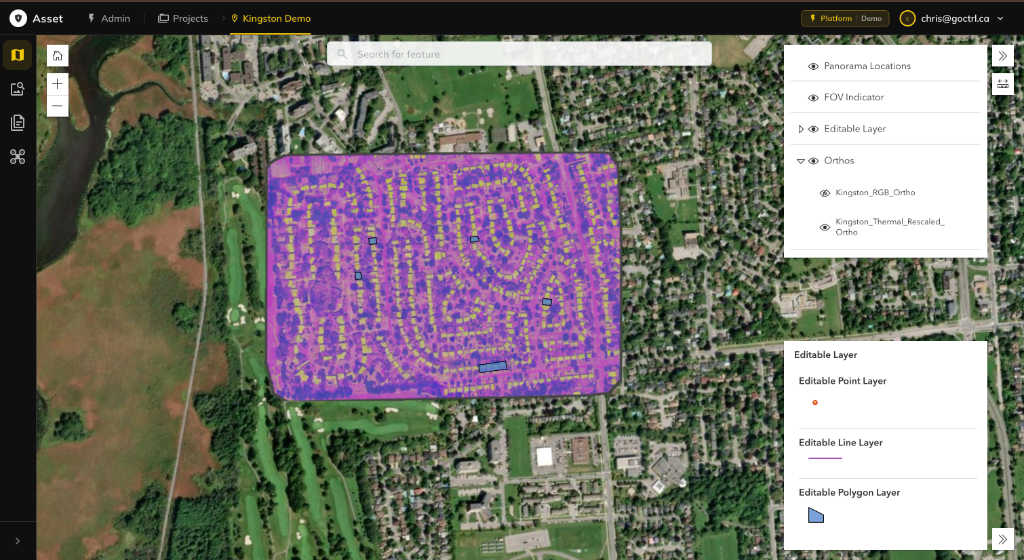
The centralized operating system for massive scale geospatial data. Ingest, visualize, and analyze datasets exceeding 50,000 images with sub-second latency.
An agent on standby, over your captured data
An agentic bot waits on your capture archive for tasking or query commands — sweep a site, surface defects, compare epochs — and returns drafted findings for review.
Built for Massive Scale
A modular architecture designed to handle datasets exceeding 50,000 images per mission.
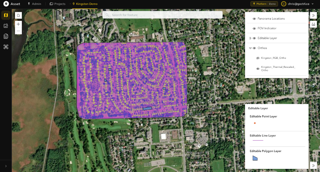
Map Viewer
Visualization at Scale
Render massive datasets with zero latency. Our proprietary tiling engine handles 50,000+ images per layer without browser lag. Toggle between 2D orthomosaics, 3D point clouds, and textured meshes instantly.
Agentic AI and LLMs at the core — verified by human industry experts
Move faster without loosening the standard. Purpose-built agents and large language models work underneath every module — ingesting multimodal capture, drafting the analysis, assembling the deliverable — then every output is reviewed and signed off by practitioners who have spent careers on these assets. Defensible, sourced, and accountable end to end.
Features
Configurable inspection and assessment routines that assemble evidence, follow your checklists, and produce audit-ready outputs every run.
Agents read PDFs, decks, and spreadsheets into a queryable knowledge graph — flagging gaps with zero manual tagging.
Analysis products are versioned and portable, so the next assessment starts from work already done instead of a blank page.
Every conclusion links back to the frame, page, or datapoint behind it — forensic sourcing with a full audit trail.
Inspect which layers were weighed and how the model reached its call. Transparent by default, always operator-overridable.
Standardized deliverables generated from live data, editable in place, exportable to the formats your clients demand.
Overlay any geospatial signal on interactive maps to see where risk concentrates across the site.
Deformation over time, capacity trends, environmental conditions — plotted so patterns read instantly.
Evidence Layers
InSAR and survey-grade movement trends across the site footprint.
Flood exposure, runoff pathways, and standing-water accumulation.
Soil classification, bearing capacity, and subsurface conditions.
Time-series imagery showing how the site has changed build-over-build.
Foundation performance indicators and instrumentation readings.
Seismic, wind, and weather hazard exposure for the location.
Third-party and neighbouring-structure risk around the perimeter.
The Math on Instrumented Inspection
Benchmarked against conventional desktop-study and rope-access workflows on utility-scale renewables and linear infrastructure. Figures reflect typical program outcomes once agentic analysis is carrying the repetitive load.
Analyst Hours per Assessment
Manual workflow vs Ctrl Asset, single site
- Manual
- Ctrl Asset
Cumulative Lifecycle Cost
Indexed to Year 1 reactive-maintenance baseline = 100
- Reactive repair
- Condition-based with Ctrl
Universal Data Support
Native support for all common geospatial formats
Aerial Imagery
- Orthomosaics
- Oblique imagery
- Panoramic photos
- 360° captures
Point Clouds
- LiDAR
- Photogrammetry
- Classified points
- 3D meshes
Raster Data
- Satellite imagery
- DEMs/DSMs
- Thermal
- Multispectral
Vector Data
- Shapefiles
- GeoJSON
- KML/KMZ
- CAD files (DWG/DXF)
Subsurface & Marine
- Bathymetry (single/multibeam)
- Ground Penetrating Radar (GPR)
- Sonar / side-scan
- Sub-bottom profiles
UGV / USV Capture
- Ground vehicle imagery
- Surface vessel imagery
- Deck & hull inspection
- Waterline / shoreline scans
Deploy Your Way
Cloud, on-premise, or hybrid Asset adapts to your infrastructure and security requirements
Cloud
FULLY MANAGED SAAS
Zero infrastructure overhead. Enterprise-grade cloud platform with automatic scaling, global CDN delivery, and 99.9% uptime SLA. Deploy in minutes, scale instantly.
- •Instant deployment & provisioning
- •Automatic scaling & load balancing
- •Global edge network (CDN)
- •Managed backups & disaster recovery
On-Premise
SELF-HOSTED DEPLOYMENT
Complete data sovereignty and control. Deploy Asset behind your firewall with full administrative access. Perfect for air-gapped networks and classified environments.
- •Deploy on your infrastructure
- •Full data sovereignty & control
- •Air-gapped network support
- •Custom security policies
Hybrid
BEST OF BOTH WORLDS
Process sensitive data on-premise while leveraging cloud capabilities for collaboration and distribution. Intelligent data routing ensures compliance while maximizing flexibility.
- •Sensitive data stays local
- •Cloud-based collaboration
- •Unified management console
- •Automatic data classification
Built for Industries That Build the World
Tailored solutions for sectors that demand precision and reliability
Construction
Monitor progress, track earthworks, and validate as-builts against design models.
Integrates With Your Stack
Native integrations with the tools you already use.
Enterprise Grade Security
Your data is protected with the highest security standards
Data Protection
- •AES-256 encryption at rest
- •TLS 1.3 encryption in transit
- •Automated backups & retention
- •Multi-region redundancy
Access Control
- •SSO (SAML, OAuth, OIDC)
- •Multi-factor authentication
- •Role-based permissions
- •Audit logging & monitoring
Compliance
- •SOC 2 Type II (pending)
- •GDPR compliant
- •HIPAA available
- •ISO 27001 (pending)
Reliability
- •99.9% uptime SLA
- •Automated failover
- •24/7 system monitoring
- •Disaster recovery plans
Built to scale with your operation
Plans start at $1,100 per seat / month and scale from mid-size teams to full enterprise deployments.
Professional
AST-PROPer-seat access for asset teams getting started
- Full asset lifecycle management
- Inspection & issue pipeline
- Standard data support
- Email support
Business
AST-BIZScaled deployment for medium-size organizations
- Unlimited seats for one org
- All Professional capabilities
- Advanced integrations & GIS layers
- Dedicated success manager
Enterprise
AST-ENTMission-critical scale across the enterprise
- Multi-org, multi-site deployment
- Palantir Foundry & Gotham integration
- Esri ArcGIS, Databricks & Snowflake pipelines
- SAP / Maximo / Salesforce asset sync
- On-prem, IL5 & gov cloud options
- 24/7 priority support & SLAs
Ready to Transform Your GIS Workflow?
Start your 14-day free trial today. No credit card required. Full access to all features.
Get in Touch.
Questions about our technology or interested in a partnership? We'd like to hear from you.